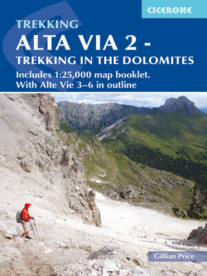
Alta Via 2--Trekking in the Dolomites
ebook ∣ Includes 1: 25,000 map booklet. With Alta Vie 3-6 in outline
By Gillian Price

Sign up to save your library
With an OverDrive account, you can save your favorite libraries for at-a-glance information about availability. Find out more about OverDrive accounts.
Share

Find this title in Libby, the library reading app by OverDrive.


Search for a digital library with this title
Title found at these libraries:
| Library Name | Distance |
|---|---|
| Loading... |
A guidebook to walking the Alta Via 2 (AV2) between Bressanone and Feltre. Covering 174km (108 miles), this long-distance trail through the western Dolomites in northeastern Italy takes about 2 weeks and is suitable for experienced trekkers with a good level of fitness.
The route is described from north to south in 13 stages, each between 8 and 22km (5–14 miles) in length. Overview maps and route descriptions for Alta Via 3, 4, 5 and 6, four harder and more remote north–south routes in the central and eastern Dolomites, are also included. Advice on 3- or 6-day sections of the route for walkers who prefer not to walk AV2 in its entirety is also given.
Share


