
Sign up to save your library
With an OverDrive account, you can save your favorite libraries for at-a-glance information about availability. Find out more about OverDrive accounts.
Share

Find this title in Libby, the library reading app by OverDrive.


Search for a digital library with this title
Title found at these libraries:
| Library Name | Distance |
|---|---|
| Loading... |
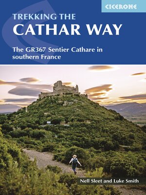
Two of the southernmost départements of France, the Pyrénées-Orientales and Ariège are inextricably linked with the history of the Cathars, a heretical Christian sect who were subjected to a crusade in the thirteenth century. Striking castles built on jagged rocky precipices are a highlight of the region and a reminder of those turbulent times. This guidebook describes the 260km Cathar Way (Sentier Cathare or GR367), a long-distance trail from Port-la-Nouvelle on the Mediterranean coast to Ariége's departmental capital Foix linking several of the impressive Cathar castles. The route follows ancient footpaths, jeep tracks and country lanes and calls for a moderate level of fitness as it sweeps from sea level to 1300m across the rugged hill ranges of the Corbières and Fenouillèdes. The guide describes the main route in 13 stages and also includes the slightly more direct north variant, as well as suggestions for shorter itineraries. Summary statistics introduce each day's walking and are followed by step-by-step route description illustrated with clear mapping. There are also details of facilities available en route and accommodation listings. An introduction covers all the practicalities, with comprehensive advice for planning your trip - including when to go, how to get there and what to take - in addition to a wealth of information about the region's fascinating history and the intriguing Cathars themselves. The trail traverses rocky hills and meanders through woodland, vineyards, ancient villages, gorges and plateaus. As well as the rich Cathar heritage, there are also historic wine-producing towns, sites associated with the French Resistance of WWII and mysterious places steeped in ancient legend. The guide is a perfect companion to discovering the Cathar Way and the captivating stories of this distinctive region.
Share


