Deluxe Then and Now Bible Maps

ebook

By Rose Publishing

cover image of Deluxe Then and Now Bible Maps

Sign up to save your library

With an OverDrive account, you can save your favorite libraries for at-a-glance information about availability. Find out more about OverDrive accounts.

   Not today

Find this title in Libby, the library reading app by OverDrive.

Download Libby on the App Store Download Libby on Google Play

Search for a digital library with this title

Title found at these libraries:

Library Name Distance
Loading...

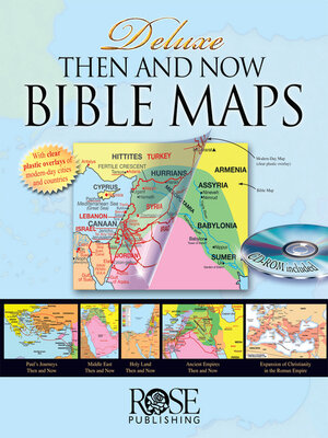
Deluxe Then and Now Bible Map Book includes full-color Bible maps with clear-plastic overlays that show modern cities and countries.

Now you can see where Bible places are today. This is the deluxe version of the #1 Bible Atlas. It includes twice as many pages as the original version, plus a CD-ROM of all the maps. The best-selling Deluxe Then and Now Bible Map Book brings new relevance to your studies and teaching, and compares Bible locations with modern-day sites.

Tell Bible stories and lead studies while presenting today's geography. Here are some examples:

  • Daniel was taken as POW to Iraq (where the ruins of Babylon are today south of Baghdad) and lived there the rest of his life
  • The ruins of Nineveh are in Northern Iraq near Mosul in Kurdish areas
  • The wise men were probably from Iran or Saudi Arabia
  • Queen Esther's throne was less than 300 miles northeast of Kuwait City
  • The CD-ROM inside the book contains all of the same maps in JPG and PDF formats so that you can use them in your own teaching material, essays, and reports. Perfect for students, Bible study leaders, pastors, professors, and others who enjoy Bible study.

    Deluxe Then and Now Bible Maps uses larger, easier-to-read type than most Bible atlases. The book is full-color and includes the following Bible maps and clear-plastic overlays that display today's cities and countries over Bible-time maps.

    The Deluxe Then and Now maps and overlays included:
  • The Middle East during Old Testament Times
  • Clear Overlay of modern-day Middle East
  • Map of the Assyrian Empire at three different time periods
  • Clear Overlay of same areas with modern-day countries
  • The Holy Land during the time of the Old Testament (12 Tribes)
  • Clear Overlay of modern-day Israel and surrounding countries
  • The Holy Land with territory of Kings Saul, David, and Solomon
  • Clear Overlay of modern-day Israel and surrounding countries
  • The Holy Land showing the United and Divided Kingdoms
  • Clear Overlay of modern-day Israel and surrounding countries
  • Map of the Babylonian Kingdoms and Persian Empire
  • Clear Overlay of same areas with modern-day countries
  • The Holy Land during the time of Jesus (and a list of where Jesus walked)
  • Clear Overlay of modern-day Holy Land
  • Paul's Journeys (Roman Empire at AD 60)
  • Clear Overlay of modern-day Mediterranean area
  • Deluxe Then and Now Bible Maps also includes these maps:
  • List of Paul's journeys and routes
  • Chart of Paul's letters (date, where written, and to whom)
  • Abraham's Journeys (2 maps)
  • Jacob's Journeys
  • Joseph's Journey to Egypt
  • The Exodus and Wilderness Wanderings
  • The Tabernacle layout (birds-eye view)
  • Map of Jerusalem at the time of Kings David and Solomon
  • Map of Jerusalem at the Time of Jesus
  • Tomb of Jesus
  • Chart of major and minor prophets, location, to whom they prophesied
  • Kingdoms of Daniel 2
  • New Testament and Old Testament Time Line
  • Journeys of Peter and Philip
  • Expansion of Christianity in the Roman...
  • Deluxe Then and Now Bible Maps