Mapping the Adirondacks
ebook ∣ Colvin, Blake, and the First True Survey of the Great Adirondack Wilderness
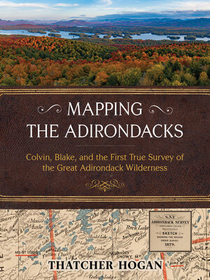
By Thatcher Hogan

Sign up to save your library
With an OverDrive account, you can save your favorite libraries for at-a-glance information about availability. Find out more about OverDrive accounts.
Share

Find this title in Libby, the library reading app by OverDrive.


Search for a digital library with this title
Title found at these libraries:
| Library Name | Distance |
|---|---|
| Loading... |
New York State's famous Adirondack landscape is immense, spanning over six million acres of public forests, lakes, rivers, mountains, and private lands. In full color featuring hundreds of detailed maps and photos, Mapping the Adirondacks celebrates it all with the first clear account of the original surveyor who explored and fully comprehended it—Verplanck Colvin. "Everywhere below," Colvin wrote, "were lakes and mountains so different from all maps, yet so immovably true."His monumental accomplishment helped motivate the citizens of New York in 1894 to legally protect it for generations to come.
As an eighteen-year-old budding travel writer, explorer and surveyor, Colvin began personally mapping a half-million acres of true Adirondack wilderness in 1865. Then, shortly after the state began partially funding his audacious project, Colvin reinvented himself as the "Superintendent" of a "Survey of the Adirondack Wilderness" and hired another equally intrepid surveyor to help—his ever-dependable friend Mills Blake. They extended the scope and granularity of their survey several times, hired hundreds of Adirondack guides and other talented people to assist, and devoted twenty-eight years to the challenge of professionally surveying the Adirondacks.
Author Thatcher Hogan has carefully gleaned narratives and illustrations from Colvin's notoriously dense annual reports and reassembled them with additional historic photographs to chronicle a compelling, true story of rugged exploration. After a novice's explanation of Colvin and Blake's surveying terms, the book follows their progress with one hundred of Hogan's new maps and summit views. The Adirondack landscape remains formidable and fascinating—many of the views are those that Colvin first discovered. Along the way, Hogan uncovers a story of intense ambition, physical hardships, and a weatherproof friendship.
The state's meager investment in their work paid off many times over. Colvin and Blake's surveys provided New York with the incontrovertible evidence needed to prevail in hundreds of complex Adirondack land disputes. Most significantly, it enabled the state to consolidate and expand its extraordinary Adirondack Forest Preserves—the prized mountains, forests, and waters of today's beloved Park.
Share


