
Sign up to save your library
With an OverDrive account, you can save your favorite libraries for at-a-glance information about availability. Find out more about OverDrive accounts.
Share

Find this title in Libby, the library reading app by OverDrive.


Search for a digital library with this title
Title found at these libraries:
| Library Name | Distance |
|---|---|
| Loading... |
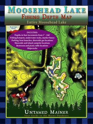
See the depths of Moosehead Lake in Full Color!
The Moosehead Lake depth maps are here! The Moosehead Lake Depth Map Atlases offer detailed 1-foot depth increments to show the contours of the bottom in full color, making it easy to find drop-offs, shallow areas, deep basins, and underwater mountains. The maps include the locations of underwater rock hazards, islands, fishing hotspots, parking, trailered & hand-carry boat launches, water-accessible fuel, picnic tables, restrooms, campsites, shipwrecks (in books 2 and 4), hazard buoys, channel buoys, no-wake zones, and the two-mile light buoy.
These maps are perfect if you love fishing, boating, canoeing, kayaking, camping, diving, & adventure on Moosehead Lake!
The maps include the locations of:
Share


